The Western Way
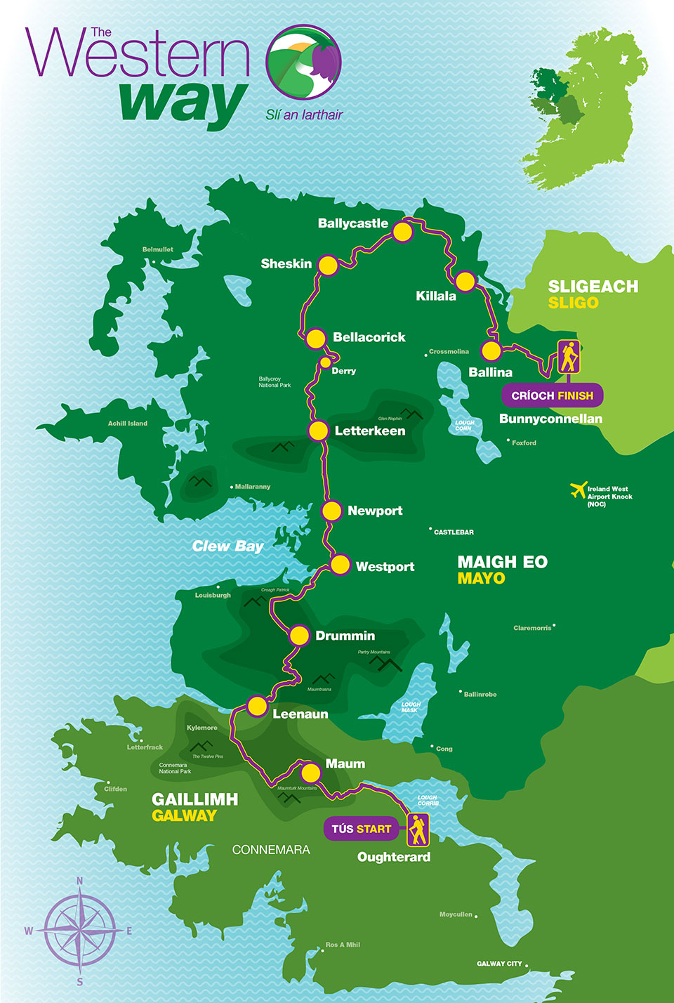
The Western Way is a long-distance walking trail taking in spectacular scenery in the counties of Galway and Mayo in the west of Ireland. The trail begins in Oughterard in County Galway and continues north toward Maum. From Maum it makes its way through the Inagh valley from where it reaches Killary Harbour near Leenane.
The Western Way enters County Mayo at Aasleagh. It then continues in a northerly direction, crossing the eastern slopes of Croagh Patrick, through Westport town to Newport. The trail passes through the Nephin Mountains to Derry, Bellacorick and Sheskin where it traverses the most remote landscape. From Ballycastle in north Mayo it follows the coastline through Killala to Ballina and on to the County Sligo border near Bunnyconnellan, over 200 kilometres from the start.

Notices
Please note the current closures on sections of the Western Way:
*The section of the Western Way between Mám Éan (53.4839994, -9.6700941) and Illion (53.5182627, -9.7206802) will be temporarily closed from July 7th to July 17th 2025. This closure is necessary to facilitate essential bridge repair works being carried out by Galway County Council.
*Due to the dangerous condition of the boardwalk and an unsafe wooden bridge, the section of the Western Way between Curran Beag (53.4748896, -9.4858508) and Maam Cross (53.4718073, -9.5363816) is impassable and will be closed until further notice – don’t not walk this section under any circumstances.
*The footbridge at Tullyconor (close to Killary Adventure centre), in the Lettershanbally Coillte forest, is currently closed until further notice, due to safety issues.
*The Bellacorick to Bunnyconnellan sections of the route will be closed until further notice.
*Warning regarding routes on Westport Greenway due to ongoing road works. Local signage in place highlighting most changes.
The Trail is mainly a Moderate grade.
Definition:
MODERATE: These trails may have some climbs and may have an uneven surface where the going is rough underfoot with some obstacles such as protruding roots, rocks etc. The routes are appropriate for people with a moderate level of fitness and some walking experience. Specific outdoor walking footwear and clothing is recommended.
Trail Map
Click on the route sections for information on each section.

Safety and Comfort
- Good hiking footwear
- Rain gear
- Trail food and drinks
- Carry a mobile phone
- Take care near streams in flood
- Take care crossing a mountain pass
- Be aware the trail passes through remote countryside
- Inform someone about your intended itinerary
Leave No Trace
- Plan ahead and prepare
- Be considerate of others
- Respect farm animals and wildlife
- Leave what you find
- Dispose of waste properly
PLEASE ADHERE TO THIS CODE IN ANY TRIP TO THE OUTDOORS
![]() TRAILHEAD
TRAILHEAD

NO DOGS ALLOWED

